News
Broward County Proposes Amendment of Priority Planning Areas for Sea Level Rise Map
October 20, 2020


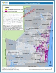
Public outreach is underway for an amendment to the Broward County Land Use Plan to update the Priority Planning Areas for Sea Level Rise Map. The map identifies areas at increased risk of flooding in accordance with the Unified Sea Level Rise Projection for Southeast Florida and a 50-year planning horizon. Applications for Land Use Plan Amendments including increasing the density of uses for properties within the priority areas are subject to review for resilience criteria. The resilience criteria requires planning for future rainfall, tidal flooding, groundwater rise, and interdependent infrastructure maintenance. Additionally, the Priority Planning Area map provides the basis for resilience review the of county’s own capital projects.
The proposed map aligns with the 40 inches (3.3 feet) of sea level rise above the 2000 mean sea level projected in 2070 following the NOAA Intermediate High Curve included in the Compact’s Unified SLR Projection. The extent of Priority Planning Areas increased by 11 square miles in response to the increase in projected sea level rise. Update of planning requirements is necessary as climate trends and predictions provide greater insight into the magnitude of adaptation needs. These investments will help provide coordinated, strategic responses to changing climatic and sea level rise conditions and thus help ensure a resilient Broward County. Comments on the proposed amendment can be emailed to resilience@broward.org.