
News
Broward County Adopts 100-Year Future Conditions Flood Map
August 5, 2021
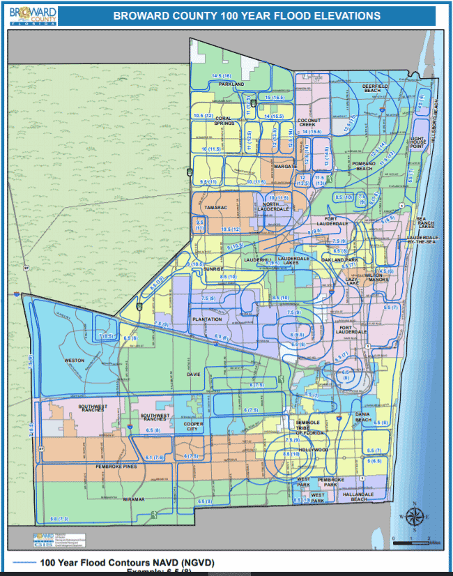
In June, the Broward County Board of County Commissioners advanced another significant milestone in furtherance of community resilience with the adoption of the Broward Future Conditions 100-year Flood Map, now established in the Broward County Code of Ordinances. This is the second future conditions map adopted by the County since the Board’s establishment of a Future Conditions Map Series in 2017. The first map developed was the Future Conditions Groundwater Table Map. Both maps were developed based on the Compact’s 2015 Regional Sea Level Rise Projection, which estimated 24 to 27 inches of rise in sea level by 2060.
The Future Conditions 100-Year Flood Map provides the basis for establishing finished floor elevations accounting for flood elevations predicted through the year 2060. It reflects the direct and negative impacts of sea level rise on coastal flooding, drainage and stormwater system discharges, and changes in the water table. The modeling effort went a step further to account for the predicted increase in rainfall intensity—modeling a 13% increase in the rainfall estimates used in the 100-year rainstorm.
Such analyses are critical to maintaining building standards that keep buildings above the 100-year flood elevation, keep people safe, reduce flood losses, and preserve the affordability of flood insurance. Further, communities that plan for sea level rise and adopt stricter standards than required by the Federal Emergency Management Agency (FEMA), have the potential to earn additional flood insurance discounts that benefit the community.
Critical next steps for Broward County include the application of the future conditions flood model in the development of a county-wide resilience plan and redevelopment strategy, focusing on optimizing water management improvements, critical services, and interconnected infrastructure.