Climate Indicators
Salt Water Intrustion
Saltwater intrusion is caused by either increasing sea levels, a reduction in inland freshwater levels, excessive groundwater pumping, or a combination of any of these factors. Lateral intrusion of saltwater from the coast is the most likely type of saltwater intrusion, particularly along Florida’s coastline. The boundary between fresh groundwater and saltwater is known as the saltwater interface. Maintaining freshwater levels or ensuring discharges to the coast prevents landward encroachment of saltwater. Saltwater intrusion can lead to contamination of coastal drinking water supplies, and in severe cases, well abandonment. Over time, saltwater has continued to intrude inland in South Florida, compromising some well fields. Significant population growth in Southeast Florida over the last several decades, combined with sea level rise, requires careful monitoring and adaptation strategies for water supply in the region.
While groundwater salinity monitoring of the Biscayne aquifer goes as far back as 1939, the South Florida Water Management District (SFWMD) began mapping the approximate location of the saltwater interface in 2009, updating maps every 5 years.
In the Compact region, the SFWMD maintains maps for Palm Beach and Broward counties, and the U.S. Geological Survey (USGS) conducts saltwater interface mapping for Miami-Dade and Monroe counties. The maps show the extent of saltwater intrusion over the period of record from sites monitored in Southeast Florida. For further information, please visit the SFWMD story map on saltwater intrusion.
In addition, the USGS Water Level and Salinity Analysis Mapper online tool provides automated
statistical and graphical analyses on (ground)water-level and salinity data collected from sites
monitored by the USGS in South Florida. The tool includes five- and 20-year trends, illustrating a
variety of localized upward and downward trends in the region, as well as the approximate inland extent of saltwater intrusion, since 2011.
Source: Data is from the South Florida Water Management District and the U.S. Geological Survey. Maps are provided courtesy of the South Florida Water Management District, 2025
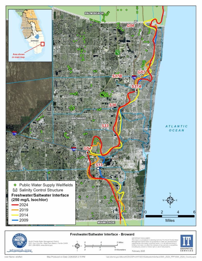
Broward County, Freshwater/Saltwater Interface
It is likely that considerable saltwater intrusion occurred in Broward County following the drainage of the Everglades. By 1945, seawater had already intruded approximately one mile inland in southern Broward County. The construction of salinity control structures since the mid-1950s has been relatively effective in slowing the progression of the saltwater front, though the proximity of some wellfields to the coast continues to lead to salinized wells that generally have to be abandoned. Saltwater intruded inland about one mile between 2009 and 2019 west of Fort Lauderdale-Hollywood International Airport near the salinity control structure S-13. In the 2024 updated maps, there is landward advancement of the saltwater front near the Peele Dixie wellfield in Fort Lauderdale, which may be partially as a result of changes in data and new data points used to produce the maps. Sea level rise is likely to contribute to further saltwater intrusion, depending on pumping and water management.
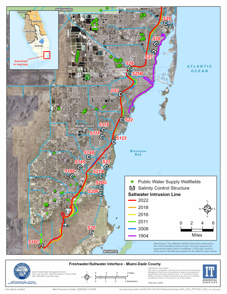
Miami-Dade County, Freshwater/Saltwater Interface
Saltwater intrusion has occurred since the drainage of the Everglades and the earliest days of groundwater withdrawal for the population of Miami-Dade County. The county’s primary water supply is the Biscayne Aquifer, which is particularly susceptible to saltwater intrusion because of its proximity to saltwater bodies and because the land-surface altitude for about 70% of the county is below 1.8 meters. By 1904 (purple line), several early wells had to be abandoned. However, the construction of salinity barriers in the canals and control of groundwater levels over the years have largely halted the further inland movement of the saltwater front across most of the county, with the exception of an area of southeastern Miami-Dade County, referred to as the Model Land Area. In 2018, USGS, in cooperation with Miami-Dade County, mapped the approximate inland extent of saltwater intrusion in Miami-Dade County and estimated the average rate of movement of the saltwater interface in the Model Land Area. The 2018 approximation of the inland extent of the saltwater interface at the base of the Biscayne Aquifer is, in most areas, farther inland than that which was mapped in 2011. Little change is seen between the 2016 front (yellow) and 2022 front (red) in most areas.
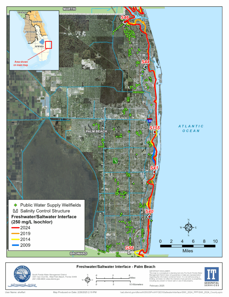
Palm Beach County, Freshwater/Saltwater Interface
Saltwater intrusion has been limited to less than one mile inland in much of Palm Beach County. Comparison of the lines below suggests that the saltwater interface has actually moved seaward in some areas between 2009/2014 and 2024. This is likely due to moving pumping centers further inland and extracting water from the deeper aquifer, although it may also be partially a result of changes in data and new data points used to produce the maps.


